
- Home >
- Stock Videos >
- Vertical cinematic reveal 3D tactical map showing illuminated roads, rivers and topography
Vertical cinematic reveal 3D tactical map showing illuminated roads, rivers and topography Video
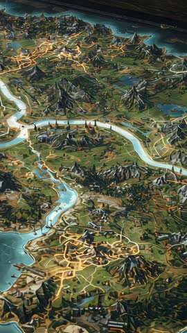
AI Generated Image. Vertical video opening with camera sliding down, revealing 3D topographic map on control table, illuminated roads and rivers tracing transport network. Ambient lighting highlighting elevation, mountain ranges, river bends and urban clusters. Animated path overlays pulsing along roads, suggesting traffic flow, logistics routing and strategic planning. Footage serving as motion background, documentary opener, urban planning presentation, military or emergency response briefing and game trailer. Optimized for vertical mobile formats, social media ads, broadcast lower-thirds and corporate explainer videos. Ideal for technology, cartography, infrastructure and GIS projects needing cinematic data visualization and terrain storytelling.
Powered by  - Get 15% off with code: PIKWIZARD15


0
downloads
downloads
Tags:
More
Credit Photo
If you would like to credit the Photo, here are some ways you can do so
Text Link
video Link
<span class="text-link">
<span>
<a target="_blank" href=https://pikwizard.com/video/vertical-cinematic-reveal-3d-tactical-map-showing-illuminated-roads-rivers-and-topography/854b4a4b64be3f649f4f454bdc83f1ae/>PikWizard</a>
</span>
</span>
<span class="image-link">
<span
style="margin: 0 0 20px 0; display: inline-block; vertical-align: middle; width: 100%;"
>
<a
target="_blank"
href="https://pikwizard.com/video/vertical-cinematic-reveal-3d-tactical-map-showing-illuminated-roads-rivers-and-topography/854b4a4b64be3f649f4f454bdc83f1ae/"
style="text-decoration: none; font-size: 10px; margin: 0;"
>
<video controls style="width: 100%; margin: 0;">
<source src="" type="video/mp4"
poster="https://pikwizard.com/pw/medium/854b4a4b64be3f649f4f454bdc83f1ae.jpg"/>
Your browser does not support the video tag.
</video>
<p style="font-size: 12px; margin: 0;">PikWizard</p>
</a>
</span>
</span>
Free (free of charge)
Free for personal and commercial use.
Author: AI Creator