
- Home >
- Stock Photos >
- Aerial View of Railroad and Highway Network with Binary Overlay
Aerial View of Railroad and Highway Network with Binary Overlay Image
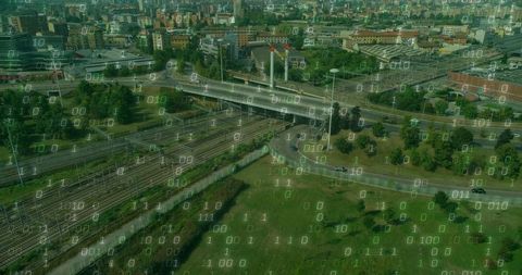
This visual portrays an intricate transportation nexus where railways and highways intersect, digitally overlaid with binary code to symbolize modern connectivity and technology integration. Ideal for use in discussions about smart city initiatives, transportation systems, digital infrastructure, and urban planning. Also useful for illustrating articles related to technological advancements in transportation or presentations emphasizing the convergence of industry and technology.
Powered by 


downloads
Tags:
More
Credit Photo
If you would like to credit the Photo, here are some ways you can do so
Text Link
photo Link
<span class="text-link">
<span>
<a target="_blank" href=https://pikwizard.com/photo/aerial-view-of-railroad-and-highway-network-with-binary-overlay/426812e7268713dda65e018b55cf42ee/>PikWizard</a>
</span>
</span>
<span class="image-link">
<span
style="margin: 0 0 20px 0; display: inline-block; vertical-align: middle; width: 100%;"
>
<a
target="_blank"
href="https://pikwizard.com/photo/aerial-view-of-railroad-and-highway-network-with-binary-overlay/426812e7268713dda65e018b55cf42ee/"
style="text-decoration: none; font-size: 10px; margin: 0;"
>
<img src="https://pikwizard.com/pw/medium/426812e7268713dda65e018b55cf42ee.jpg" style="margin: 0; width: 100%;" alt="" />
<p style="font-size: 12px; margin: 0;">PikWizard</p>
</a>
</span>
</span>
Free (free of charge)
Free for personal and commercial use.
Author: Authentic Images