- Home >
- Stock Photos >
- Augmented Reality with Digital Map Pin Over Aerial Field Landscape
Augmented Reality with Digital Map Pin Over Aerial Field Landscape Image
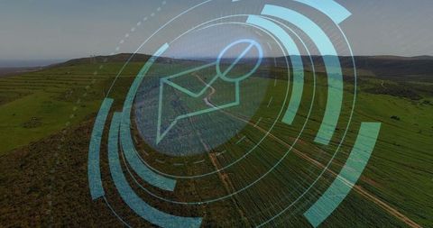
Image showcases augmented reality technology integrating with geographic fields. Overlay of a digital map pin and concentric circles suggests advanced navigation systems in agriculture. Ideal for illustrating modern farming, innovative mapping technologies, or satellite-based geographic data solutions.
Powered by  - Get 15% off with code: PIKWIZARD15


0
downloads
downloads
Tags:
More
Credit Photo
If you would like to credit the Photo, here are some ways you can do so
Text Link
photo Link
<span class="text-link">
<span>
<a target="_blank" href=https://pikwizard.com/photo/augmented-reality-with-digital-map-pin-over-aerial-field-landscape/6c9036514f74bdfdbe3a57c37c6f958b/>PikWizard</a>
</span>
</span>
<span class="image-link">
<span
style="margin: 0 0 20px 0; display: inline-block; vertical-align: middle; width: 100%;"
>
<a
target="_blank"
href="https://pikwizard.com/photo/augmented-reality-with-digital-map-pin-over-aerial-field-landscape/6c9036514f74bdfdbe3a57c37c6f958b/"
style="text-decoration: none; font-size: 10px; margin: 0;"
>
<img src="https://pikwizard.com/pw/medium/6c9036514f74bdfdbe3a57c37c6f958b.jpg" style="margin: 0; width: 100%;" alt="" />
<p style="font-size: 12px; margin: 0;">PikWizard</p>
</a>
</span>
</span>
Free (free of charge)
Free for personal and commercial use.
Author: Creative Art
Similar Free Stock Images