
- Home >
- Free Stock Videos >
- Aerial Geospatial Visualization Showing Coastal Fields and Ocean with HUD Grid Overlay
Aerial Geospatial Visualization Showing Coastal Fields and Ocean with HUD Grid Overlay Free Stock Video
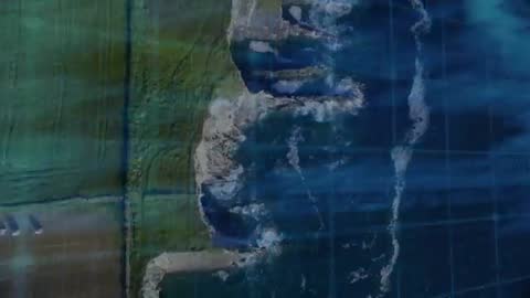
Showing drone aerial footage of rugged coastline meeting green agricultural fields with translucent teal HUD grid and code overlay revealing geospatial data across sea and land. Waves crashing against cliffs appearing through layered digital grid while subtle camera pan moving along coast. Overlaying satellite-style mapping elements, floating data points and scanlines creating high-tech visualization. Color palette featuring deep ocean blues and teal highlights. Serving geospatial presentations, environmental reports, coastal erosion studies, technology commercials, sci-fi openers, news graphics and corporate tech branding. Enhancing intros, title sequences, background loops, on-screen graphics for GIS demos, interactive mapping apps, social media posts and website hero sections. Preparing for edit by adding text overlays, animating data points, adjusting color grade to match brand or compositing custom map layers.
Powered by  - Get 15% off with code: PIKWIZARD15


downloads
Tags:
More
Credit Photo
If you would like to credit the Photo, here are some ways you can do so
Text Link
video Link
<span class="text-link">
<span>
<a target="_blank" href=https://pikwizard.com/video/aerial-geospatial-visualization-showing-coastal-fields-and-ocean-with-hud-grid-overlay/60ec494f3686e743e75e1ec8a5e37da5/>PikWizard</a>
</span>
</span>
<span class="image-link">
<span
style="margin: 0 0 20px 0; display: inline-block; vertical-align: middle; width: 100%;"
>
<a
target="_blank"
href="https://pikwizard.com/video/aerial-geospatial-visualization-showing-coastal-fields-and-ocean-with-hud-grid-overlay/60ec494f3686e743e75e1ec8a5e37da5/"
style="text-decoration: none; font-size: 10px; margin: 0;"
>
<video controls style="width: 100%; margin: 0;">
<source src="https://player.vimeo.com/progressive_redirect/playback/1178749218/rendition/240p/file.mp4%20%28240p%29.mp4?loc=external&oauth2_token_id=1223210874&signature=061f1dc6c91f6e07b5c2a271c557421f6f79e2eae828cec8f66cc106e17526a5" type="video/mp4"
poster="https://thumbs.wbm.im/pw/medium/60ec494f3686e743e75e1ec8a5e37da5.jpg"/>
Your browser does not support the video tag.
</video>
<p style="font-size: 12px; margin: 0;">PikWizard</p>
</a>
</span>
</span>
Free (free of charge)
Free for personal and commercial use.
Author: Awesome Content