
- Home >
- Stock Videos >
- Curved Screen Showing Neon Street Grid Map with Reflective Floor in Futuristic Control Hub
Curved Screen Showing Neon Street Grid Map with Reflective Floor in Futuristic Control Hub Video
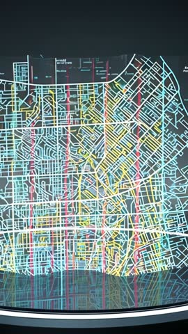
AI Generated Image. Video showing curved translucent screen presenting neon-colored street grid map in dark room with reflective floor. Animated lines pulsing and subtle glow effects emphasizing major corridors and intersections. Vertical orientation optimizing mobile and social platform playback, tailoring 9:16 delivery and loopable presentation. Use for showcasing urban planning concepts, smart city dashboards, navigation technology demos, futuristic control room sequences, motion graphics backgrounds, or broadcast segments on city infrastructure. Production tips: overlaying logos and lower thirds, adding animated data labels and heatmap layers, color grading to match brand palette, adjusting animation speed for mood. Licensing ideas: intro for tech conference videos, background for GIS or transportation presentations, social media promos for mapping startups, B-roll for documentary or news segments.
Powered by  - Get 15% off with code: PIKWIZARD15


0
downloads
downloads
Tags:
More
Credit Photo
If you would like to credit the Photo, here are some ways you can do so
Text Link
video Link
<span class="text-link">
<span>
<a target="_blank" href=https://pikwizard.com/video/curved-screen-showing-neon-street-grid-map-with-reflective-floor-in-futuristic-control-hub/456f9c157e589fd768f5afa86e66aa3d/>PikWizard</a>
</span>
</span>
<span class="image-link">
<span
style="margin: 0 0 20px 0; display: inline-block; vertical-align: middle; width: 100%;"
>
<a
target="_blank"
href="https://pikwizard.com/video/curved-screen-showing-neon-street-grid-map-with-reflective-floor-in-futuristic-control-hub/456f9c157e589fd768f5afa86e66aa3d/"
style="text-decoration: none; font-size: 10px; margin: 0;"
>
<video controls style="width: 100%; margin: 0;">
<source src="" type="video/mp4"
poster="https://pikwizard.com/pw/medium/456f9c157e589fd768f5afa86e66aa3d.jpg"/>
Your browser does not support the video tag.
</video>
<p style="font-size: 12px; margin: 0;">PikWizard</p>
</a>
</span>
</span>
Free (free of charge)
Free for personal and commercial use.
Author: AI Creator