
- Home >
- Stock Videos >
- Drone View with Mapping Overlay Over Coastal Terrain
Drone View with Mapping Overlay Over Coastal Terrain Video
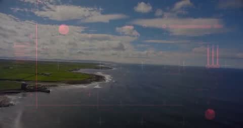
Depicting the vast view of fields leading to a rocky coastline, this scene blends advanced aerial technology with natural beauty. Vibrant patches of fields and the gentle meeting of land and ocean under a clear sky highlight the potential of using such videos for geographical surveys, algorithm testing in agricultural innovations, or web posts on sustainable technologies. Useful for materials showcasing the intersection of modern drone artistry and nature.
Powered by  - Get 15% off with code: PIKWIZARD15


downloads
Tags:
More
Credit Photo
If you would like to credit the Photo, here are some ways you can do so
Text Link
video Link
<span class="text-link">
<span>
<a target="_blank" href=https://pikwizard.com/video/drone-view-with-mapping-overlay-over-coastal-terrain/b07cb2ba5abc4cba0dfac44d626b76fb/>PikWizard</a>
</span>
</span>
<span class="image-link">
<span
style="margin: 0 0 20px 0; display: inline-block; vertical-align: middle; width: 100%;"
>
<a
target="_blank"
href="https://pikwizard.com/video/drone-view-with-mapping-overlay-over-coastal-terrain/b07cb2ba5abc4cba0dfac44d626b76fb/"
style="text-decoration: none; font-size: 10px; margin: 0;"
>
<video controls style="width: 100%; margin: 0;">
<source src="https://player.vimeo.com/progressive_redirect/playback/1078010685/rendition/240p/file.mp4?loc=external&oauth2_token_id=1223210874&signature=546f54f36ca883b86063ac8de180cc7a88705205e3f83d1b2a34c0c07d79272c" type="video/mp4"
poster="https://pikwizard.com/pw/medium/b07cb2ba5abc4cba0dfac44d626b76fb.jpg"/>
Your browser does not support the video tag.
</video>
<p style="font-size: 12px; margin: 0;">PikWizard</p>
</a>
</span>
</span>
Free (free of charge)
Free for personal and commercial use.
Author: Awesome Content