
- Home >
- Stock Videos >
- Global Data Mapping Over Mountainous Landscape with Visualized Coding
Global Data Mapping Over Mountainous Landscape with Visualized Coding Video
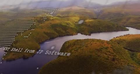
Aerial view showcases terrain with flowing river interrupted by digital elements like a dotted world map and scrolling code, creating an abstract mix of nature and technology. This hybrid portrayal is ideal for projects emphasizing big data analysis, technological innovation, environmental tech initiatives, and digital communication transformations.

downloads
Tags:
More
Credit Photo
If you would like to credit the Photo, here are some ways you can do so
Text Link
video Link
<span class="text-link">
<span>
<a target="_blank" href=https://pikwizard.com/video/global-data-mapping-over-mountainous-landscape-with-visualized-coding/d6ba6bbe7cb64fcb6c65ef704345c6c3/>PikWizard</a>
</span>
</span>
<span class="image-link">
<span
style="margin: 0 0 20px 0; display: inline-block; vertical-align: middle; width: 100%;"
>
<a
target="_blank"
href="https://pikwizard.com/video/global-data-mapping-over-mountainous-landscape-with-visualized-coding/d6ba6bbe7cb64fcb6c65ef704345c6c3/"
style="text-decoration: none; font-size: 10px; margin: 0;"
>
<video controls style="width: 100%; margin: 0;">
<source src="https://player.vimeo.com/progressive_redirect/playback/1100033852/rendition/240p/file.mp4?loc=external&oauth2_token_id=1223210874&signature=713085202eeaff5176b0a6b23d4172b6ff3686d7bf37feac011209a5d3a47eac" type="video/mp4"
poster="https://pikwizard.com/pw/medium/d6ba6bbe7cb64fcb6c65ef704345c6c3.jpg"/>
Your browser does not support the video tag.
</video>
<p style="font-size: 12px; margin: 0;">PikWizard</p>
</a>
</span>
</span>
Free (free of charge)
Free for personal and commercial use.
Author: Awesome Content