
- Home >
- Stock Videos >
- Historic Trade Routes Explored on AI-Generated Relief Map
Historic Trade Routes Explored on AI-Generated Relief Map Video
AI
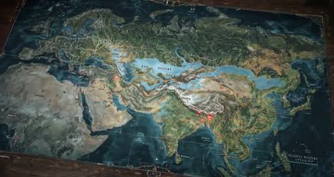
AI Generated Video. A detailed relief map stretched across a study table with pulsing red markers highlights historic trade routes, beautifully captured by AI-generated digital art. This immersive exploration tool showcases navigation and geopolitics, perfect for AI and map enthusiasts, educators, and students interested in history and cultural exchange. This visualization is ideal for educational purposes or creative projects in fields like academic research and digital storytelling.
Powered by  - Get 15% off with code: PIKWIZARD15


downloads
Tags:
More
Credit Photo
If you would like to credit the Photo, here are some ways you can do so
Text Link
video Link
<span class="text-link">
<span>
<a target="_blank" href=https://pikwizard.com/video/historic-trade-routes-explored-on-ai-generated-relief-map/9be0b6378552287d20e19860ed52b060/>PikWizard</a>
</span>
</span>
<span class="image-link">
<span
style="margin: 0 0 20px 0; display: inline-block; vertical-align: middle; width: 100%;"
>
<a
target="_blank"
href="https://pikwizard.com/video/historic-trade-routes-explored-on-ai-generated-relief-map/9be0b6378552287d20e19860ed52b060/"
style="text-decoration: none; font-size: 10px; margin: 0;"
>
<video controls style="width: 100%; margin: 0;">
<source src="https://player.vimeo.com/progressive_redirect/playback/1115011623/rendition/240p/file.mp4?loc=external&oauth2_token_id=1223210874&signature=d874721329cb427af080b62f47b44d0be85ec2f579c1fe70bbe88e57ca1a0d6e" type="video/mp4"
poster="https://pikwizard.com/pw/medium/9be0b6378552287d20e19860ed52b060.jpg"/>
Your browser does not support the video tag.
</video>
<p style="font-size: 12px; margin: 0;">PikWizard</p>
</a>
</span>
</span>
Free (free of charge)
Free for personal and commercial use.
Author: AI Creator