
- Home >
- Free Stock Videos >
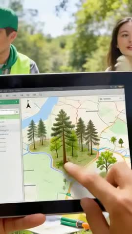
- Vertical video: Pointing tablet map with 3D trees for forestry mapping and field teamwork
Vertical video: Pointing tablet map with 3D trees for forestry mapping and field teamwork Free Stock Video
AI
AI Generated Video. Pointing finger tapping and panning tablet map, selecting 3D tree models to visualize forest layout. Man wearing neon vest and cap standing left, colleague appearing right, both appearing blurred to emphasize tablet interface. Scene capturing field planning workflow, combining GIS data with on-site verification and collaborative decision making. Video working well for software demo, training clip, client presentation, social media ad, environmental education short. Suggested uses: showcasing forest inventory app, promoting geospatial services, illustrating collaborative field surveys, training field crews on mobile mapping tools, creating vertical-format ads for mobile platforms.
Powered by  - Get 15% off with code: PIKWIZARD15


downloads
Tags:
More
Credit Photo
If you would like to credit the Photo, here are some ways you can do so
Text Link
video Link
<span class="text-link">
<span>
<a target="_blank" href=https://pikwizard.com/video/vertical-video-pointing-tablet-map-with-3d-trees-for-forestry-mapping-and-field-teamwork/2983f38205f76b7209dddc279db2bb13/>PikWizard</a>
</span>
</span>
<span class="image-link">
<span
style="margin: 0 0 20px 0; display: inline-block; vertical-align: middle; width: 100%;"
>
<a
target="_blank"
href="https://pikwizard.com/video/vertical-video-pointing-tablet-map-with-3d-trees-for-forestry-mapping-and-field-teamwork/2983f38205f76b7209dddc279db2bb13/"
style="text-decoration: none; font-size: 10px; margin: 0;"
>
<video controls style="width: 100%; margin: 0;">
<source src="https://player.vimeo.com/progressive_redirect/playback/1186133989/rendition/240p/file.mp4%20%28240p%29.mp4?loc=external&oauth2_token_id=1223210874&signature=0e23cb0af0d9ab04867e56906a2ecb2646582001c7150b3feda50a3cd246b0c8" type="video/mp4"
poster="https://thumbs.wbm.im/pw/medium/2983f38205f76b7209dddc279db2bb13.jpg"/>
Your browser does not support the video tag.
</video>
<p style="font-size: 12px; margin: 0;">PikWizard</p>
</a>
</span>
</span>
Free (free of charge)
Free for personal and commercial use.
Author: AI Creator